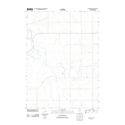
2011 Map of Center East
USGS Topo · Published 2011About this map
Bazile Creek and its many winding tributaries, including Little Bazile Creek, define this rural section of Knox County as it appeared in the early 21st century. The landscape is characterized by a high-density network of section roads, primarily designated by avenues and numbered roads such as 534 Ave and 875 Rd. For family researchers, Kemma Cemetery stands as a significant landmark in the central portion of the quadrangle, situated near the intersection of 535 Ave and 877 Way. The layout of the road system, including Nebraska Highway 84, illustrates the enduring grid-based agricultural development of the region, where natural drainage patterns and modern infrastructure intersect.
Find a feature on this map
20 named features on this map. Tap any name to fly to it.
Don’t see what you’re looking for? This feature index may not catch every label — zoom into the map to look around manually.
Map Details
Editions of this 2011 Center East Map
This is the sole edition of this map. No revisions or reprints were ever made.
Other maps of this area

1955 · Sioux City
USGS Topo · 1:250,000

1958 · Sioux City
USGS Topo · 1:250,000

1959 · Sioux City
USGS Topo · 1:250,000

1974 · Sparta
USGS Topo · 1:24,000

1974 · Lindy
USGS Topo · 1:24,000

1974 · Midland
USGS Topo · 1:24,000
1974 · Center West
USGS Topo · 1:24,000
1974 · Creighton
USGS Topo · 1:24,000

1974 · Bloomfield
USGS Topo · 1:24,000
1974 · Plainview NE
USGS Topo · 1:24,000