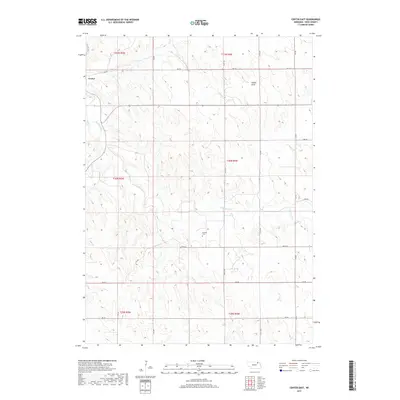
2017 Map of Center East
USGS Topo · Published 2017About this map
Center stands at the northwestern edge of this landscape in Knox County, serving as a focal point for a region defined by its dissected upland drainage systems. The terrain is deeply etched by the branching paths of Bazile Creek and Little Bazile Cr, which create a complex network of ridges and valleys across the township sections. One of the more prominent topographic depressions, Walker Draw, cuts through the northern sections, illustrating the natural water-flow patterns that have dictated the placement of local infrastructure. A notable point for family historians is the Kemma Cem, situated centrally among the section lines of Township 30 North, Range 4 West. The map's grid of section roads, such as 882 RD and 536th Ave, reveals a rural development pattern that remains tethered to the original Public Land Survey System layout.
Find a feature on this map
24 named features on this map. Tap any name to fly to it.
Don’t see what you’re looking for? This feature index may not catch every label — zoom into the map to look around manually.
Map Details
Editions of this 2017 Center East Map
This is the sole edition of this map. No revisions or reprints were ever made.
Other maps of this area

1955 · Sioux City
USGS Topo · 1:250,000

1958 · Sioux City
USGS Topo · 1:250,000

1959 · Sioux City
USGS Topo · 1:250,000

1974 · Sparta
USGS Topo · 1:24,000

1974 · Lindy
USGS Topo · 1:24,000

1974 · Midland
USGS Topo · 1:24,000
1974 · Center West
USGS Topo · 1:24,000
1974 · Creighton
USGS Topo · 1:24,000

1974 · Bloomfield
USGS Topo · 1:24,000
1974 · Plainview NE
USGS Topo · 1:24,000