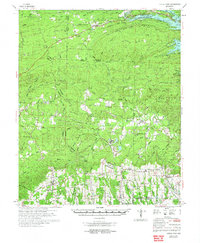
1972 Map of Center Point
USGS Topo · Published 1973About this map
Center Point sits in the southern portion of this region, surrounded by a landscape defined by small communities and rural religious centers in the early 1970s. The map illustrates the complex water management systems of the era, centered on the Lake Greeson reservoir and the Narrows Dam. This area exhibits a distinct industrial and agricultural blend, featuring numerous gravel pits, shale pits, and specialized minnow ponds near Newhope. Local transportation and commerce are anchored by the Mississippi Southwestern Railroad and the De Queen and Eastern Railroad, which navigate the terrain between Pine Mountain and Wildcat Bluff. Genealogists will find a wealth of specific data points, from the Mt Pleasant Cem to remote rural congregations like Sweet Home Ch and Green Plains Ch, providing a detailed record of the social geography across Howard and Pike counties.
Find a feature on this map
107 named features on this map. Tap any name to fly to it.
Don’t see what you’re looking for? This feature index may not catch every label — zoom into the map to look around manually.
Map Details
Editions of this 1972 Center Point Map
This is the sole edition of this map. No revisions or reprints were ever made.
Other maps of this area

1906 · Caddo Gap
USGS Topo · 1:125,000

1913 · De Queen
USGS Topo · 1:125,000

1936 · Athens
USGS Topo · 1:48,000

1936 · Glenwood
USGS Topo · 1:48,000

1942 · Glenwood
USGS Topo · 1:62,500

1942 · Athens
USGS Topo · 1:62,500

1949 · Glenwood
USGS Topo · 1:62,500

1950 · Mcalester
USGS Topo · 1:250,000

1951 · Mineral Springs North
USGS Topo · 1:24,000

1951 · Nashville
USGS Topo · 1:24,000