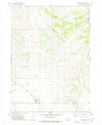
1974 Map of Center West
USGS Topo · Published 1978About this map
Winnetoon and the county seat of Center anchor this mid-1970s survey of Knox County, Nebraska. The landscape is defined by the sharp transition between the agricultural plateau and the deeply carved valleys of Bazile Creek and Spring Creek. The Santee Indian Reservation Boundary cuts across the northern third of the map, marking a significant historical and jurisdictional line in the region. Transportation and local industry are visible through the path of the Chicago and North Western railroad and several Gravel Pits scattered near the watercourses. Smaller communities like Bazile Mills and landmarks such as the Herbert Landing Strip provide evidence of rural settlement patterns and aviation history in this corner of the state, while the Cedar Hill Cem remains as a focal point for genealogical research.
Find a feature on this map
14 named features on this map. Tap any name to fly to it.
Don’t see what you’re looking for? This feature index may not catch every label — zoom into the map to look around manually.
Map Details
Editions of this 1974 Center West Map
This is the sole edition of this map. No revisions or reprints were ever made.
Other maps of this area

1950 · Verdigre NE
USGS Topo · 1:24,000

1954 · Verdigre
USGS Topo · 1:24,000

1955 · Sioux City
USGS Topo · 1:250,000

1955 · O'Neill
USGS Topo · 1:250,000

1958 · Sioux City
USGS Topo · 1:250,000

1959 · O'Neill
USGS Topo · 1:250,000

1959 · Sioux City
USGS Topo · 1:250,000

1963 · Orchard NE
USGS Topo · 1:24,000

1969 · O'Neill
USGS Topo · 1:250,000

1974 · Sparta
USGS Topo · 1:24,000