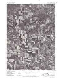
1977 Map of Center West
USGS Topo · Published 1979About this map
Bazile Creek winds through the northeast corner of this Knox County landscape, where the small settlements of Center and Bazile Mills sit along its banks. Produced in cooperation with the Bureau of Indian Affairs, this 1977 orthophotograph provides a clear overhead record of the region's agricultural patterns and rural layout. The grid of section lines and gravel roads connects the village of Winnetoon in the southwest to the wooded drainage of the creek in the north. This document captures the transition between the rolling hills and the structured farmland typical of northeastern Nebraska, offering a precise view of field boundaries and homestead locations as they existed in the late 1970s.
Find a feature on this map
5 named features on this map. Tap any name to fly to it.
Don’t see what you’re looking for? This feature index may not catch every label — zoom into the map to look around manually.
Map Details
Editions of this 1977 Center West Map
This is the sole edition of this map. No revisions or reprints were ever made.
Other maps of this area

1950 · Verdigre NE
USGS Topo · 1:24,000

1954 · Verdigre
USGS Topo · 1:24,000

1955 · Sioux City
USGS Topo · 1:250,000

1955 · O'Neill
USGS Topo · 1:250,000

1958 · Sioux City
USGS Topo · 1:250,000

1959 · O'Neill
USGS Topo · 1:250,000

1959 · Sioux City
USGS Topo · 1:250,000

1963 · Orchard NE
USGS Topo · 1:24,000

1969 · O'Neill
USGS Topo · 1:250,000

1974 · Sparta
USGS Topo · 1:24,000