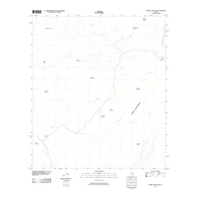
2010 Map of Cerro Castellan
USGS Topo · Published 2010About this map
Cerro Castellan stands as a prominent landmark in this desert landscape, where the Chisos Mountains meet the drainage systems of Blue Creek and Smoky Creek. The terrain is defined by dramatic volcanic and erosional features, including the striking Mule Ear Peaks and the geological formation of Tuff Canyon. Essential water sources are scattered throughout this arid environment, marked by sites like Mule Ear Spring, Trap Spring, and Tule Spring, which historically dictated movement through the area. Human access is facilitated by the Ross Maxwell Scenic Dr, providing vantage points such as the Sotol Vista Overlook and Mule Ear Overlook. Other notable high points like Goat Mountain and Trap Mountain rise above the surrounding flats, while the Burro Mesa Pouroff illustrates the powerful impact of seasonal water flow on the local topography.
Find a feature on this map
21 named features on this map. Tap any name to fly to it.
Don’t see what you’re looking for? This feature index may not catch every label — zoom into the map to look around manually.
Map Details
Editions of this 2010 Cerro Castellan Map
This is the sole edition of this map. No revisions or reprints were ever made.
Other maps of this area

1903 · Chisos Mountains
USGS Topo · 1:125,000

1903 · Terlingua
USGS Topo · 1:125,000

1904 · Terlingua
USGS Topo · 1:125,000

1905 · Chisos Mountains
USGS Topo · 1:125,000

1959 · Emory Peak
USGS Topo · 1:250,000

1965 · Emory Peak
USGS Topo · 1:250,000

1971 · Terlingua
USGS Topo · 1:24,000

1971 · Cerro Castellan
USGS Topo · 1:24,000
1971 · Reed Camp
USGS Topo · 1:24,000
1971 · Tule Mountain
USGS Topo · 1:24,000