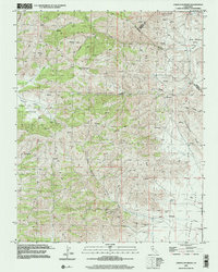
2000 Map of Cerro Colorado
USGS Topo · Published 2002About this map
Cerro Colorado anchors this landscape in the southern Diablo Range, a region marked by steep canyons and isolated valleys. The map illustrates a rugged interior topography where water is scarce, indicated by numerous springs and isolated Water Tanks scattered across the Real De Las Aguilas land grant. Historically, this area was a focus for small-scale mining operations, evidenced by the presence of the Mercey Mine in the north and a cluster including the Lucky Strike Mine and Lone Oak Mine farther south.
Find a feature on this map
24 named features on this map. Tap any name to fly to it.
Don’t see what you’re looking for? This feature index may not catch every label — zoom into the map to look around manually.
Map Details
Editions of this 2000 Cerro Colorado Map
This is the sole edition of this map. No revisions or reprints were ever made.
Other maps of this area

1913 · Panoche
USGS Topo · 1:125,000

1919 · San Benito
USGS Topo · 1:62,500

1921 · Laguna Seca Ranch
USGS Topo · 1:31,680

1922 · Quien Sabe
USGS Topo · 1:62,500

1923 · Laguna Seca Ranch
USGS Topo · 1:31,680

1931 · San Benito
USGS Topo · 1:62,500

1940 · Quien Sabe
USGS Topo · 1:62,500

1940 · San Benito
USGS Topo · 1:62,500

1943 · Ortigalita Peak
USGS Topo · 1:62,500

1944 · Panoche Valley
USGS Topo · 1:62,500