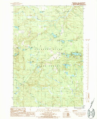
1986 Map of Chabeneau Lake
USGS Topo · Published 1986About this map
The Escanaba River winds through the heart of this Marquette County landscape, bisecting a region defined by its timber and mineral potential within the Escumbo State Forest. This 1980s-era documentation highlights the industrial and communication infrastructure that supported the Upper Peninsula, featuring several communication points like Radio Tower WNMU and Radio Tower WLUC. The presence of an Old Railroad Grade and a Rock Quarry speaks to the historical extraction and transportation networks that once moved resources through the forest. Numerous small bodies of water, including Chabeneau Lake, Lake Francoeur, and the uniquely named Tanglefoot Lake, are scattered across the terrain, connected by a network of drainage ways like Whiskey Creek and Sagola Creek. A remote Landing Field further illustrates the specialized land use in this sparsely populated section of Michigan.
Find a feature on this map
35 named features on this map. Tap any name to fly to it.
Don’t see what you’re looking for? This feature index may not catch every label — zoom into the map to look around manually.
Map Details
Editions of this 1986 Chabeneau Lake Map
This is the sole edition of this map. No revisions or reprints were ever made.
Other maps of this area

1952 · Ishpeming
USGS Topo · 1:62,500

1952 · Ishpeming
USGS Topo · 1:24,000

1955 · Ralph NW
USGS Topo · 1:24,000

1955 · Ralph NE
USGS Topo · 1:24,000

1955 · Greenwood
USGS Topo · 1:24,000

1955 · Republic
USGS Topo · 1:62,500

1955 · Republic
USGS Topo · 1:24,000

1955 · Republic SW
USGS Topo · 1:24,000

1955 · Ralph
USGS Topo · 1:62,500

1957 · Northland
USGS Topo · 1:62,500