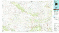
1977 Map of Chaco Mesa
USGS Topo · Published 1993About this map
Chaco Mesa dominates this high-desert landscape in the late 1970s, where the Continental Divide winds through a region defined by complex drainage systems like Chaco Wash and Chico Arroyo. The map reveals a specific cultural and economic network of the era, marked by established remote outposts such as Star Lake Trading Post, Johnson Trading Post, and Prairie Dog Trading Post. These locations, along with settlements like Whitehorse and Hospah, illustrate the enduring reliance on trading centers in this corner of McKinley and Sandoval counties.
Find a feature on this map
171 named features on this map. Tap any name to fly to it.
Don’t see what you’re looking for? This feature index may not catch every label — zoom into the map to look around manually.
Map Details
Editions of this 1977 Chaco Mesa Map
2 editions found
Other maps of this area

1883 · Mt. Taylor
USGS Topo · 1:250,000

1886 · Wingate
USGS Topo · 1:250,000

1886 · Mt. Taylor
USGS Topo · 1:250,000

1888 · Bernalillo
USGS Topo · 1:125,000

1889 · Albuquerque
USGS Topo · 1:125,000

1889 · Largo
USGS Topo · 1:250,000

1889 · Chaco
USGS Topo · 1:250,000

1890 · Jemes
USGS Topo · 1:125,000

1892 · Jemes
USGS Topo · 1:125,000

1892 · Wingate
USGS Topo · 1:250,000