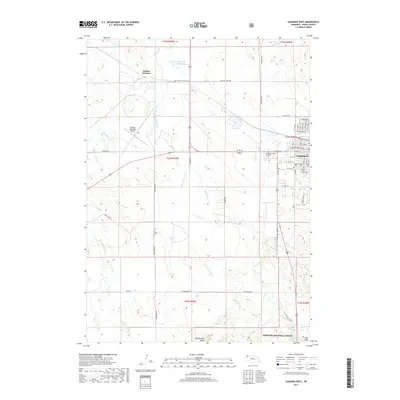
2017 Map of Chadron West
USGS Topo · Published 2017About this map
Chadron sits at the edge of the high plains, serving as a regional hub defined by the academic presence of Chadron State College and its proximity to the northern escarpments of the Pine Ridge. The landscape transitions from the urban grid of the city, marked by Greenwood Cem and Calvary Cem, into the open ranching and agricultural lands of Dawes County. To the northwest, Dakota Junction indicates the historical importance of rail connections, while the White River and Chadron Cr carve drainage patterns through the terrain. The southern portion of the map is dominated by the protected lands of the Nebraska National Forest, where the topography rises toward Rattlesnake Butte. This 2017 survey details the modern infrastructure of the area, including the Chadron Municipal Airport and a network of rural roads like Deadhorse Rd and Buttermilk Rd that connect isolated landmarks such as Shisler Cem.
Find a feature on this map
51 named features on this map. Tap any name to fly to it.
Don’t see what you’re looking for? This feature index may not catch every label — zoom into the map to look around manually.
Map Details
Editions of this 2017 Chadron West Map
This is the sole edition of this map. No revisions or reprints were ever made.
Other maps of this area

1955 · Alliance
USGS Topo · 1:250,000

1957 · Alliance
USGS Topo · 1:250,000

1958 · Alliance
USGS Topo · 1:250,000
1970 · Bohemian Creek
USGS Topo · 1:24,000

1970 · Chadron 3 NW
USGS Topo · 1:24,000
1970 · Chadron East
USGS Topo · 1:24,000
1970 · Isinglass Buttes
USGS Topo · 1:24,000
1980 · Coffee Mill Butte
USGS Topo · 1:24,000

1980 · Wayside
USGS Topo · 1:24,000
1980 · Trunk Butte
USGS Topo · 1:24,000