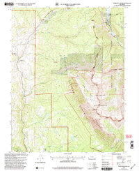
2001 Map of Chair Mountain
USGS Topo · Published 2004About this map
Gunnison National Forest and White River National Forest converge in this high-altitude landscape dominated by the dramatic topography of The Raggeds. The 2001 revision illustrates a transition from the agricultural operations at Jacobs Ranch and Chair Mtn Ranch to the protected wildlands of the Raggeds Wilderness. Evidence of resource management and early development appears in the presence of Prospects on the mountain slopes and the engineering of the Twin Forks Ditch and Tomahawk Reservoir. The hydrologic network is anchored by the Crystal River in the northeast, while East Muddy Creek and its various tributaries like Lee Creek and Grouse Creek carve through the western reaches. This survey records the late-twentieth-century balance between working ranch lands and federally managed wilderness in the Colorado high country.
Find a feature on this map
52 named features on this map. Tap any name to fly to it.
Don’t see what you’re looking for? This feature index may not catch every label — zoom into the map to look around manually.
Map Details
Editions of this 2001 Chair Mountain Map
This is the sole edition of this map. No revisions or reprints were ever made.
Other maps of this area

1888 · Anthracite
USGS Topo · 1:62,500

1889 · Anthracite
USGS Topo · 1:62,500

1893 · Anthracite
USGS Topo · 1:62,500

1894 · Anthracite
USGS Topo · 1:62,500

1938 · Mt. Gunnison
USGS Topo · 1:48,000

1945 · Mount Gunnison
USGS Topo · 1:62,500

1956 · Montrose
USGS Topo · 1:250,000

1957 · Leadville
USGS Topo · 1:250,000

1959 · Leadville
USGS Topo · 1:250,000

1959 · Montrose
USGS Topo · 1:250,000