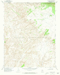
1970 Map of Chaiyahi Flat
USGS Topo · Published 1973About this map
Navajo Mountain anchors the northeastern corner of this 1970 landscape, where the high desert terrain of the Navajo Indian Reservation drops into a complex network of canyons and mesas. Located along the Utah Arizona border in San Juan and Coconino counties, the map documents cultural and geological landmarks including the Rainbow Lodge (Site) and the Round Rock Ruins. The topography is defined by the broad Chaiyahi Flat and distinctive formations like Cummings Octagon Butte and Balanced Rock Mesa. Water is a critical and scarce element here, represented by seasonal features such as Rainbow Lodge Spring, Tsagieto Canyon, and Trampled Water Canyon. The presence of a single Jeep Trail suggests the extreme isolation of this area, which remains a place of significant archaeological interest and traditional indigenous importance.
Find a feature on this map
23 named features on this map. Tap any name to fly to it.
Don’t see what you’re looking for? This feature index may not catch every label — zoom into the map to look around manually.
Map Details
Editions of this 1970 Chaiyahi Flat Map
This is the sole edition of this map. No revisions or reprints were ever made.
Other maps of this area

1883 · Marsh Pass
USGS Topo · 1:250,000

1886 · Escalante
USGS Topo · 1:250,000

1886 · Henry Mountains
USGS Topo · 1:250,000

1886 · Echo Cliffs
USGS Topo · 1:250,000

1891 · Echo Cliffs
USGS Topo · 1:250,000

1892 · Marsh Pass
USGS Topo · 1:250,000

1892 · Henry Mountains
USGS Topo · 1:250,000

1953 · Cummings Mesa
USGS Topo · 1:62,500

1953 · Navajo Mountain
USGS Topo · 1:62,500

1954 · Navajo Creek
USGS Topo · 1:62,500