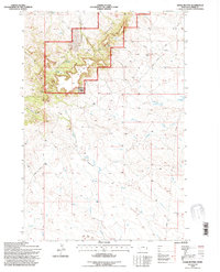
1993 Map of Chalk Buttes
USGS Topo · Published 1996About this map
Custer National Forest encompasses the prominent high ground of the Chalk Buttes, a region defined by its isolated ranching outposts and strategic water sources. In the early 1990s, the landscape remained characterized by a network of family-held properties such as the E Elmore Ranch and L Smith Ranch, connected by primitive roads and a singular Landing Strip near Laird Ranch. The terrain drops from the timbered heights of the forest into the expansive Blue Mud Hills and the winding drainages of Buffalo Creek and Chito Creek. Numerous named springs, including Alderman Spring and Foster Spring, underscore the vital role of water management in this arid Montana cattle country. The presence of a Pipeline and occasional Drill Hole locations suggest the quiet encroachment of industrial infrastructure into the traditional grazing lands of southern Carter County.
Find a feature on this map
25 named features on this map. Tap any name to fly to it.
Don’t see what you’re looking for? This feature index may not catch every label — zoom into the map to look around manually.
Map Details
Editions of this 1993 Chalk Buttes Map
This is the sole edition of this map. No revisions or reprints were ever made.
Other maps of this area

1954 · Ekalaka
USGS Topo · 1:250,000

1956 · Ekalaka
USGS Topo · 1:250,000

1958 · Ekalaka
USGS Topo · 1:250,000

1965 · Ekalaka
USGS Topo · 1:250,000

1979 · W L Butte
USGS Topo · 1:24,000

1979 · Dutchman Creek
USGS Topo · 1:24,000

1979 · Blacktail Creek SE
USGS Topo · 1:24,000

1979 · Beaver Flats South
USGS Topo · 1:24,000

1979 · Dead Boy Divide
USGS Topo · 1:24,000

1979 · Ikey Creek
USGS Topo · 1:24,000