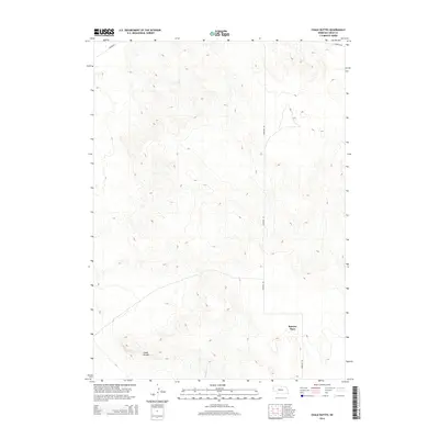
2014 Map of Chalk Buttes
USGS Topo · Published 2014About this map
The Chalk Buttes dominate the southern landscape of this Sheep Creek Precinct survey, where high plains topography meets intermittent watercourses. The local ranching and agricultural heritage is anchored by the Spurior Place, a specific named homestead located near the eastern edge of the quadrangle. Transportation across this section of Sioux County is defined by a sparse network of unpaved tracks, including Moore Rd and Harrison Rd, which follow the natural contours of the terrain. The presence of Dry Sheep Cr illustrates the arid nature of this environment, where drainage patterns are often seasonal. This survey captures a moment in the modern era where family-named landmarks and traditional land divisions remain central to the geography of the Nebraska panhandle.
Find a feature on this map
6 named features on this map. Tap any name to fly to it.
Don’t see what you’re looking for? This feature index may not catch every label — zoom into the map to look around manually.
Map Details
Editions of this 2014 Chalk Buttes Map
This is the sole edition of this map. No revisions or reprints were ever made.
Other maps of this area

1896 · Patrick
USGS Topo · 1:125,000

1899 · Whistle Creek
USGS Topo · 1:125,000

1954 · Torrington
USGS Topo · 1:250,000

1955 · Alliance
USGS Topo · 1:250,000

1957 · Alliance
USGS Topo · 1:250,000

1958 · Torrington
USGS Topo · 1:250,000

1958 · Alliance
USGS Topo · 1:250,000

1963 · Chalk Buttes
USGS Topo · 1:24,000
1963 · Torrington SE
USGS Topo · 1:24,000
1963 · Erdman Ranch
USGS Topo · 1:24,000