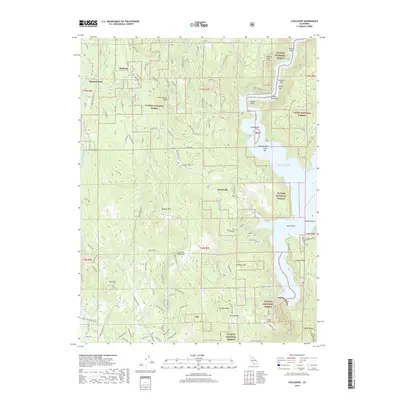
2018 Map of Challenge
USGS Topo · Published 2018About this map
Sharon Valley and the neighboring settlement of Challenge occupy the northern reaches of this Yuba County landscape, situated amidst the expansive timberlands of the Plumas National Forest. The eastern portion of the map is dominated by the deep waters of the New Bullards Bar Reservoir, which flooded the North Yuba River canyon, leaving behind remnants of the older riverine geography such as Frenchy Point, Long Bar, and Rock Island Bar. The terrain is defined by high ridges and peaks, including Pike County Peak and Oregon Peak, with numerous creeks like Slapjack Cr and Indian Cr carving deep drainage patterns toward the reservoir. In the southern sector near Girot Ridge, the Colgate Tunnel indicates the area's infrastructure for water management and power generation, while smaller settlements like Greenville and Oregon Hills are connected by a network of forest service roads and local routes such as La Porte Rd.
Find a feature on this map
119 named features on this map. Tap any name to fly to it.
Don’t see what you’re looking for? This feature index may not catch every label — zoom into the map to look around manually.
Map Details
Editions of this 2018 Challenge Map
This is the sole edition of this map. No revisions or reprints were ever made.
Other maps of this area

1888 · Smartsville
USGS Topo · 1:125,000

1888 · Bidwell Bar
USGS Topo · 1:125,000

1891 · Bidwell Bar
USGS Topo · 1:125,000

1891 · Smartsville
USGS Topo · 1:125,000

1892 · Smartsville
USGS Topo · 1:125,000

1893 · Bidwell Bar
USGS Topo · 1:125,000

1894 · Smartsville
USGS Topo · 1:125,000

1895 · Bidwell Bar
USGS Topo · 1:125,000

1895 · Smartsville
USGS Topo · 1:125,000

1897 · Bidwell Bar
USGS Topo · 1:125,000