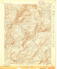
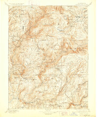
1897 Map of Bidwell Bar
USGS Topo · Published 1897About this map
Gold-era mining settlements and industrial outposts define this high-country landscape during the late nineteenth century. The map captures a transition where remote Sierra Nevada outposts like Spanish Ranch and Bucks Ranch served as vital hubs for travelers and laborers moving between the various forks of the Feather River. Resource extraction is evident in the numerous sites scattered through the canyons, including Snows Mine near Table Mt. and several lumber processing points such as Old Defiance Mill, Hutchins Mill, and Big Bar Mill. Local life centered around established stops like Bidwell Bar and Forbestown, while the geography is heavily influenced by the drainage basins of Bucks Creek and Spanish Creek. The cartography by R.H. Mc. Kee. delineates the county lines separating Plumas, Butte, and Sierra counties, illustrating the administrative complexity of these gold-bearing mountain ranges.
Find a feature on this map
152 named features on this map. Tap any name to fly to it.
Don’t see what you’re looking for? This feature index may not catch every label — zoom into the map to look around manually.
Map Details
Editions of this 1897 Bidwell Bar Map
7 editions found
Historical Maps of Woodleaf Through Time
177 maps found

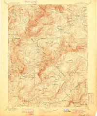
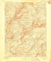
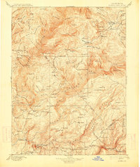
1888 Bidwell Bar
Plumas County, CA

1891 Bidwell Bar
Plumas County, CA

1893 Bidwell Bar
Plumas County, CA

1895 Bidwell Bar
Plumas County, CA

1897 Bidwell Bar
Plumas County, CA

1948 American House
Plumas County, CA

1948 Mooreville Ridge
Plumas County, CA

1950 American House
Plumas County, CA

1950 Chilcoot
Plumas County, CA

1950 Kettle Rock
Plumas County, CA

1950 Onion Valley
Plumas County, CA

1951 Blue Nose Mtn
Plumas County, CA

1951 Onion Valley
Plumas County, CA

1956 Mt. Harkness
Plumas County, CA

1958 Jonesville
Plumas County, CA

1972 Antelope Lake
Plumas County, CA

1972 Babcock Peak
Plumas County, CA

1972 Crocker Mtn
Plumas County, CA

1972 Dixie Mountain
Plumas County, CA

1972 Genesee Valley
Plumas County, CA

1972 Grizzly Valley
Plumas County, CA

1972 Kettle Rock
Plumas County, CA

1972 Mt. Ingalls
Plumas County, CA

1972 Reconnaissance Peak
Plumas County, CA

1977 Ferris Creek
Plumas County, CA

1977 Squaw Valley Peak
Plumas County, CA

1979 Chilcoot
Plumas County, CA

1979 Dogwood Peak
Plumas County, CA

1979 Frenchman Lake
Plumas County, CA

1979 Red Cinder
Plumas County, CA

1979 Soapstone Hill
Plumas County, CA

1979 Storrie
Plumas County, CA

1980 Haskins Valley
Plumas County, CA

1980 Moonlight Peak
Plumas County, CA

1980 Westwood West
Plumas County, CA

1985 Mt. Harkness
Plumas County, CA

1985 Reading Peak
Plumas County, CA

1985 Stover Mountain
Plumas County, CA

1991 Humbug Valley
Plumas County, CA

1994 American House
Plumas County, CA

1994 Antelope Lake
Plumas County, CA

1994 Babcock Peak
Plumas County, CA

1994 Blue Nose Mountain
Plumas County, CA

1994 Chilcoot
Plumas County, CA

1994 Crocker Mountain
Plumas County, CA

1994 Dixie Mountain
Plumas County, CA

1994 Dogwood Peak
Plumas County, CA

1994 Ferris Creek
Plumas County, CA

1994 Frenchman Lake
Plumas County, CA

1994 Genesee Valley
Plumas County, CA

1994 Grizzly Valley
Plumas County, CA

1994 Haskins Valley
Plumas County, CA

1994 Kettle Rock
Plumas County, CA

1994 Moonlight Peak
Plumas County, CA

1994 Mount Ingalls
Plumas County, CA

1994 Onion Valley
Plumas County, CA

1994 Reconnaissance Peak
Plumas County, CA

1994 Soapstone Hill
Plumas County, CA

1994 Squaw Valley Peak
Plumas County, CA

1994 Storrie
Plumas County, CA

1995 Humbug Valley
Plumas County, CA

1995 Mount Harkness
Plumas County, CA

1995 Reading Peak
Plumas County, CA

1995 Red Cinder
Plumas County, CA

1995 Stover Mountain
Plumas County, CA

1995 Westwood West
Plumas County, CA

2012 American House
Plumas County, CA

2012 Antelope Lake
Plumas County, CA

2012 Babcock Peak
Plumas County, CA

2012 Blue Nose Mountain
Plumas County, CA

2012 Chilcoot
Plumas County, CA

2012 Crocker Mountain
Plumas County, CA

2012 Dixie Mountain
Plumas County, CA

2012 Dogwood Peak
Plumas County, CA

2012 Ferris Creek
Plumas County, CA

2012 Frenchman Lake
Plumas County, CA

2012 Genesee Valley
Plumas County, CA

2012 Grizzly Valley
Plumas County, CA

2012 Haskins Valley
Plumas County, CA

2012 Humbug Valley
Plumas County, CA

2012 Kettle Rock
Plumas County, CA

2012 Moonlight Peak
Plumas County, CA

2012 Mount Harkness
Plumas County, CA

2012 Mount Ingalls
Plumas County, CA

2012 Onion Valley
Plumas County, CA

2012 Reading Peak
Plumas County, CA

2012 Reconnaissance Peak
Plumas County, CA

2012 Red Cinder
Plumas County, CA

2012 Ross Canyon
Plumas County, CA

2012 Soapstone Hill
Plumas County, CA

2012 Storrie
Plumas County, CA

2012 Stover Mountain
Plumas County, CA

2012 Westwood West
Plumas County, CA

2015 American House
Plumas County, CA

2015 Antelope Lake
Plumas County, CA

2015 Babcock Peak
Plumas County, CA

2015 Blue Nose Mountain
Plumas County, CA

2015 Chilcoot
Plumas County, CA

2015 Crocker Mountain
Plumas County, CA

2015 Dixie Mountain
Plumas County, CA

2015 Dogwood Peak
Plumas County, CA

2015 Ferris Creek
Plumas County, CA

2015 Frenchman Lake
Plumas County, CA

2015 Genesee Valley
Plumas County, CA

2015 Grizzly Valley
Plumas County, CA

2015 Haskins Valley
Plumas County, CA

2015 Humbug Valley
Plumas County, CA

2015 Kettle Rock
Plumas County, CA

2015 Moonlight Peak
Plumas County, CA

2015 Mount Harkness
Plumas County, CA

2015 Mount Ingalls
Plumas County, CA

2015 Onion Valley
Plumas County, CA

2015 Reading Peak
Plumas County, CA

2015 Reconnaissance Peak
Plumas County, CA

2015 Red Cinder
Plumas County, CA

2015 Ross Canyon
Plumas County, CA

2015 Soapstone Hill
Plumas County, CA

2015 Storrie
Plumas County, CA

2015 Stover Mountain
Plumas County, CA

2015 Westwood West
Plumas County, CA

2018 American House
Plumas County, CA

2018 Antelope Lake
Plumas County, CA

2018 Babcock Peak
Plumas County, CA

2018 Blue Nose Mountain
Plumas County, CA

2018 Chilcoot
Plumas County, CA

2018 Crocker Mountain
Plumas County, CA

2018 Dixie Mountain
Plumas County, CA

2018 Dogwood Peak
Plumas County, CA

2018 Ferris Creek
Plumas County, CA

2018 Frenchman Lake
Plumas County, CA

2018 Genesee Valley
Plumas County, CA

2018 Grizzly Valley
Plumas County, CA

2018 Haskins Valley
Plumas County, CA

2018 Humbug Valley
Plumas County, CA

2018 Kettle Rock
Plumas County, CA

2018 Moonlight Peak
Plumas County, CA

2018 Mount Harkness
Plumas County, CA

2018 Mount Ingalls
Plumas County, CA

2018 Onion Valley
Plumas County, CA

2018 Reading Peak
Plumas County, CA

2018 Reconnaissance Peak
Plumas County, CA

2018 Red Cinder
Plumas County, CA

2018 Ross Canyon
Plumas County, CA

2018 Soapstone Hill
Plumas County, CA

2018 Storrie
Plumas County, CA

2018 Stover Mountain
Plumas County, CA

2018 Westwood West
Plumas County, CA

2021 American House
Plumas County, CA

2021 Babcock Peak
Plumas County, CA

2021 Blue Nose Mountain
Plumas County, CA

2021 Chilcoot
Plumas County, CA

2021 Crocker Mountain
Plumas County, CA

2021 Dixie Mountain
Plumas County, CA

2021 Ferris Creek
Plumas County, CA

2021 Grizzly Valley
Plumas County, CA

2021 Haskins Valley
Plumas County, CA

2021 Humbug Valley
Plumas County, CA

2021 Moonlight Peak
Plumas County, CA

2021 Mount Ingalls
Plumas County, CA

2021 Onion Valley
Plumas County, CA

2021 Reading Peak
Plumas County, CA

2021 Reconnaissance Peak
Plumas County, CA

2021 Ross Canyon
Plumas County, CA

2021 Stover Mountain
Plumas County, CA

2021 Westwood West
Plumas County, CA

2022 Antelope Lake
Plumas County, CA

2022 Dogwood Peak
Plumas County, CA

2022 Frenchman Lake
Plumas County, CA

2022 Genesee Valley
Plumas County, CA

2022 Kettle Rock
Plumas County, CA

2022 Mount Harkness
Plumas County, CA

2022 Red Cinder
Plumas County, CA

2022 Soapstone Hill
Plumas County, CA

2022 Storrie
Plumas County, CA

2023 Babcock Peak
Plumas County, CA

2023 Crocker Mountain
Plumas County, CA

2023 Ross Canyon
Plumas County, CA