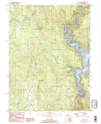
1995 Map of Challenge
USGS Topo · Published 1995About this map
Oregon Hills define this corner of the northern Sierra foothills, where the New Bullards Bar Reservoir fills the deep canyons of the North Yuba River. This 1995 provisional survey illustrates a landscape managed by the Plumas National Forest and Tahoe National Forest, with a network of logging roads and forest service infrastructure like the Calif Dept of For Fire Sta. The map serves as a vital record for local history, showing family-named locations such as Baker Ranch, Burns Ranch, and Cummings Ranch alongside the historic Keystone Cemetery. These small holdings and settlements like Challenge and Greenville reflect the persistent human footprint in a region shaped by timber and water management, punctuated by engineering works like the New Bullards Bar Dam and the Colgate Tunnel.
Find a feature on this map
53 named features on this map. Tap any name to fly to it.
Don’t see what you’re looking for? This feature index may not catch every label — zoom into the map to look around manually.
Map Details
Editions of this 1995 Challenge Map
This is the sole edition of this map. No revisions or reprints were ever made.
Other maps of this area

1888 · Smartsville
USGS Topo · 1:125,000

1888 · Bidwell Bar
USGS Topo · 1:125,000

1891 · Bidwell Bar
USGS Topo · 1:125,000

1891 · Smartsville
USGS Topo · 1:125,000

1892 · Smartsville
USGS Topo · 1:125,000

1893 · Bidwell Bar
USGS Topo · 1:125,000

1894 · Smartsville
USGS Topo · 1:125,000

1895 · Bidwell Bar
USGS Topo · 1:125,000

1895 · Smartsville
USGS Topo · 1:125,000

1897 · Bidwell Bar
USGS Topo · 1:125,000