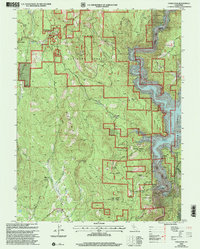
2000 Map of Challenge
USGS Topo · Published 2003About this map
The Bullards Bar Reservoir dominates the eastern edge of this landscape, a deep impoundment where Bullards Creek and the North Fork Yuba River once met before the construction of the New Bullards Bar Dam. The surrounding terrain is a mosaic of public lands within the Plumas National Forest and Tahoe National Forest, marked by steep ridges such as Pike County Peak and Oregon Peak.
Find a feature on this map
68 named features on this map. Tap any name to fly to it.
Don’t see what you’re looking for? This feature index may not catch every label — zoom into the map to look around manually.
Map Details
Editions of this 2000 Challenge Map
This is the sole edition of this map. No revisions or reprints were ever made.
Other maps of this area

1888 · Smartsville
USGS Topo · 1:125,000

1888 · Bidwell Bar
USGS Topo · 1:125,000

1891 · Bidwell Bar
USGS Topo · 1:125,000

1891 · Smartsville
USGS Topo · 1:125,000

1892 · Smartsville
USGS Topo · 1:125,000

1893 · Bidwell Bar
USGS Topo · 1:125,000

1894 · Smartsville
USGS Topo · 1:125,000

1895 · Bidwell Bar
USGS Topo · 1:125,000

1895 · Smartsville
USGS Topo · 1:125,000

1897 · Bidwell Bar
USGS Topo · 1:125,000