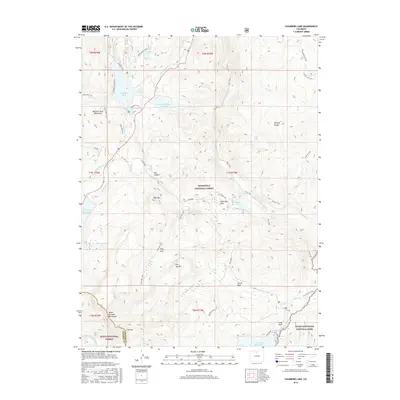
2016 Map of Chambers Lake
USGS Topo · Published 2016About this map
The Medicine Bow Mountains, Mummy Range, and Never Summer Mountains converge in this high-elevation landscape, defining a critical hydrologic divide where the headwaters of the Laramie River and the Cache la Poudre River originate. The 2016 survey illustrates a complex network of water management and recreation centered around Chambers Lake and its associated Chambers Lake CG. Significant infrastructure including the Barnes Meadow Reservoir, Joe Wright Reservoir, and Long Draw Reservoir reflects the region's importance for water storage and transport via the Long Draw Road. The terrain is marked by distinctive alpine basins such as Trap Park and Corral Park, alongside the narrow Box Canyon. This map serves as a detailed record of the intersections between the Roosevelt National Forest, Routt National Forest, and Rocky Mountain National Park, tracing the trails and roads that provide access to high peaks like Bald Mtn and Iron Mtn.
Find a feature on this map
52 named features on this map. Tap any name to fly to it.
Don’t see what you’re looking for? This feature index may not catch every label — zoom into the map to look around manually.
Map Details
Editions of this 2016 Chambers Lake Map
This is the sole edition of this map. No revisions or reprints were ever made.
Other maps of this area

1915 · Longs Peak
USGS Topo · 1:125,000

1916 · Home
USGS Topo · 1:125,000

1919 · Rocky Mountain National Park
USGS Topo · 1:125,000

1920 · Home
USGS Topo · 1:125,000

1954 · Greeley
USGS Topo · 1:250,000

1957 · Greeley
USGS Topo · 1:250,000

1957 · Trail Ridge
USGS Topo · 1:24,000

1957 · Mount Richthofen
USGS Topo · 1:24,000

1958 · Greeley
USGS Topo · 1:250,000
1958 · Fall River Pass
USGS Topo · 1:24,000