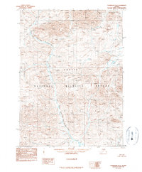
1990 Map of Chandalar D-1
USGS Topo · Published 1990About this map
The Arctic National Wildlife Refuge dominates this landscape, encompassing the entire region documented in this 1990 provisional study. The terrain is defined by the complex hydrology of the North Fork East Fork Chandalar River, which winds through the central and western portions of the quadrangle. As a provisional map produced from original manuscript drawings, the document focuses on the natural topography and water systems rather than man-made infrastructure. The lack of roads, trails, or settlements reflects the intentional preservation of this interior Alaskan wilderness, where the primary features are the nameless peaks and the intricate drainages feeding the Chandalar River system.
Find a feature on this map
2 named features on this map. Tap any name to fly to it.
Don’t see what you’re looking for? This feature index may not catch every label — zoom into the map to look around manually.
Map Details
Editions of this 1990 Chandalar D-1 Map
This is the sole edition of this map. No revisions or reprints were ever made.
Other maps of this area

1951 · Chandalar
USGS Topo · 1:250,000

1951 · Christian
USGS Topo · 1:250,000

1951 · Brooks
USGS Topo · 1:250,000

1951 · Arctic
USGS Topo · 1:250,000

1956 · Arctic
USGS Topo · 1:250,000

1956 · Chandalar
USGS Topo · 1:250,000

1956 · Philip Smith Mountains
USGS Topo · 1:250,000

1956 · Christian
USGS Topo · 1:250,000

1964 · Chandalar
USGS Topo · 1:250,000

1964 · Philip Smith Mountains
USGS Topo · 1:250,000