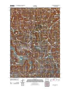
2011 Map of Chapin Creek
USGS Topo · Published 2011About this map
Hayden Prairie and Miller Prairie define the high plateau landscape of Morrow County in this 2011 survey. The terrain is deeply incised by a network of drainages, most notably Chapin Creek, which winds past Chapin Meadow and Tree Root Canyon. To the north, Buck Falls and Waterfall mark the steep descent into Stevens Canyon, while Shingle Mill Butte stands as a prominent landmark above the creek.
Find a feature on this map
58 named features on this map. Tap any name to fly to it.
Don’t see what you’re looking for? This feature index may not catch every label — zoom into the map to look around manually.
Map Details
Editions of this 2011 Chapin Creek Map
This is the sole edition of this map. No revisions or reprints were ever made.
Other maps of this area
1953 · Kimberly
USGS Topo · 1:62,500
1953 · Spray
USGS Topo · 1:62,500

1953 · Pendleton
USGS Topo · 1:250,000

1955 · Canyon City
USGS Topo · 1:250,000

1956 · Pendleton
USGS Topo · 1:250,000

1959 · Canyon City
USGS Topo · 1:250,000
1969 · Lefevre Prairie
USGS Topo · 1:24,000
1969 · Buttermilk Canyon
USGS Topo · 1:24,000
1969 · Chapin Creek
USGS Topo · 1:24,000
1969 · Hardman
USGS Topo · 1:24,000