
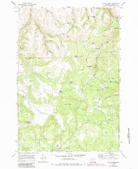
1969 Map of Chapin Creek
USGS Topo · Published 1973About this map
Umatilla National Forest land defines the eastern and southern portions of this landscape, where the high basalt plateaus of Morrow County meet steep-walled canyons. The topography is marked by distinctive level reaches such as Lava Flat and Camas Prairie, which provide a sharp contrast to the deeply incised drainages of Chapin Creek and Camas Creek. Natural springs are the primary landmarks here, including Hasting Spring, Merrill Spring, and Wild Spring, often indicating essential water sources for the cattle ranching that persists in the area. Evidence of historical land use appears in features like Shingle Mill Butte and the Anson Wright Memorial Park near the northeastern boundary. The map reveals a network of primitive transportation, with a Jeep Trail winding through the northern canyons and a series of named saddles and meadows like Burton Saddle and McDonald Meadow that served as navigational waypoints for early travelers and land managers.
Find a feature on this map
47 named features on this map. Tap any name to fly to it.
Don’t see what you’re looking for? This feature index may not catch every label — zoom into the map to look around manually.
Map Details
Editions of this 1969 Chapin Creek Map
2 editions found
Other maps of this area

1953 · Kimberly
USGS Topo · 1:62,500

1953 · Spray
USGS Topo · 1:62,500

1953 · Pendleton
USGS Topo · 1:250,000

1955 · Canyon City
USGS Topo · 1:250,000

1956 · Pendleton
USGS Topo · 1:250,000

1959 · Canyon City
USGS Topo · 1:250,000

1969 · Lefevre Prairie
USGS Topo · 1:24,000

1969 · Buttermilk Canyon
USGS Topo · 1:24,000

1969 · Hardman
USGS Topo · 1:24,000

1969 · Big Rock Flat
USGS Topo · 1:24,000