
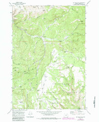
1969 Map of Big Rock Flat
USGS Topo · Published 1973About this map
Reeds Mill and Parkers Mill sit along Three Rock Creek in this late 1960s survey of the high plateau region in Morrow and Grant Counties. Much of the southern landscape is dominated by the Umatilla National Forest, where a network of family-named landmarks such as Harrington Spring, Shaner Spring, and Davidson Canyon indicates the deep history of ranching and resource use in the Oregon interior. The map illustrates a high-desert environment where water is the primary organizing force, evidenced by the high density of named seeps like Morphine Spring, Sperry Spring, and Opal Spring. The isolated Big Rock Flat Airstrip on Big Rock Flat suggests the vast distances of this terrain, while Anson Wright Memorial Park serves as a lone recreational landmark near the western boundary along Route 207.
Find a feature on this map
67 named features on this map. Tap any name to fly to it.
Don’t see what you’re looking for? This feature index may not catch every label — zoom into the map to look around manually.
Map Details
Editions of this 1969 Big Rock Flat Map
2 editions found
Other maps of this area

1951 · Monument
USGS Topo · 1:62,500

1953 · Kimberly
USGS Topo · 1:62,500

1953 · Pendleton
USGS Topo · 1:250,000

1955 · Canyon City
USGS Topo · 1:250,000

1956 · Pendleton
USGS Topo · 1:250,000

1959 · Canyon City
USGS Topo · 1:250,000

1969 · Summerfield Ridge
USGS Topo · 1:24,000

1969 · Chapin Creek
USGS Topo · 1:24,000

1969 · Madison Butte
USGS Topo · 1:24,000

1969 · Hardman
USGS Topo · 1:24,000