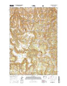
2014 Map of Chapin Creek
USGS Topo · Published 2014About this map
Umatilla National Forest encompasses a significant portion of this high-elevation landscape in Morrow County, where a network of forest roads and historic grades navigates a complex system of buttes and canyons. The Heppner-Spray Hwy serves as the primary artery through this terrain, passing through Hayden Prairie and near Camas Prairie. The landscape is characterized by open expanses like Lava Flat and Chapin Meadow, interspersed with prominent landmarks such as Lone Pine Butte and Shingle Mill Butte.
Find a feature on this map
71 named features on this map. Tap any name to fly to it.
Don’t see what you’re looking for? This feature index may not catch every label — zoom into the map to look around manually.
Map Details
Editions of this 2014 Chapin Creek Map
This is the sole edition of this map. No revisions or reprints were ever made.
Other maps of this area
1953 · Kimberly
USGS Topo · 1:62,500
1953 · Spray
USGS Topo · 1:62,500

1953 · Pendleton
USGS Topo · 1:250,000

1955 · Canyon City
USGS Topo · 1:250,000

1956 · Pendleton
USGS Topo · 1:250,000

1959 · Canyon City
USGS Topo · 1:250,000
1969 · Lefevre Prairie
USGS Topo · 1:24,000
1969 · Buttermilk Canyon
USGS Topo · 1:24,000
1969 · Chapin Creek
USGS Topo · 1:24,000
1969 · Hardman
USGS Topo · 1:24,000