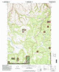
1995 Map of Chapin Creek
USGS Topo · Published 1998About this map
Umatilla National Forest encompasses much of this Morrow County landscape, where the high desert terrain of eastern Oregon is marked by a series of buttes, canyons, and essential water sources. The map reveals a land defined by its prairies and springs, such as Miller Prairie and Hasting Prairie, which provided critical grazing and stopping points in an arid environment. High points like Camas Butte and Lone Pine Butte overlook a complex drainage system including Chapin Creek and Camas Creek. Small human imprints appear in the form of Indian Camp and Baker Gardens, while Anson Wright Memorial Park serves as a landmark at the eastern edge. The topography is further punctuated by geological features like Lava Flat and the crossing at French Pass, illustrating the logistical challenges and landmarks used by early travelers and forest rangers.
Find a feature on this map
60 named features on this map. Tap any name to fly to it.
Don’t see what you’re looking for? This feature index may not catch every label — zoom into the map to look around manually.
Map Details
Editions of this 1995 Chapin Creek Map
This is the sole edition of this map. No revisions or reprints were ever made.
Other maps of this area

1953 · Kimberly
USGS Topo · 1:62,500

1953 · Spray
USGS Topo · 1:62,500

1953 · Pendleton
USGS Topo · 1:250,000

1955 · Canyon City
USGS Topo · 1:250,000

1956 · Pendleton
USGS Topo · 1:250,000

1959 · Canyon City
USGS Topo · 1:250,000

1969 · Lefevre Prairie
USGS Topo · 1:24,000

1969 · Buttermilk Canyon
USGS Topo · 1:24,000

1969 · Chapin Creek
USGS Topo · 1:24,000

1969 · Hardman
USGS Topo · 1:24,000