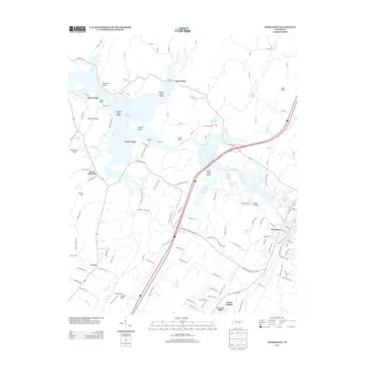
2013 Map of Charleston
USGS Topo · Published 2013About this map
The Hiwassee River cuts a wide path across this portion of Bradley County, defining the landscape between Charleston and Lamontville. This riverine environment is marked by numerous natural springs and landings that have long served as local landmarks, including Bradford Spring, Russell Spring, and Renslow Spring. The presence of Grays Ferry and Raht Ferry crossings points to the historical importance of the river as both a barrier and a thoroughfare for the surrounding valleys.
Find a feature on this map
140 named features on this map. Tap any name to fly to it.
Don’t see what you’re looking for? This feature index may not catch every label — zoom into the map to look around manually.
Map Details
Editions of this 2013 Charleston Map
This is the sole edition of this map. No revisions or reprints were ever made.
Other maps of this area

1886 · Cleveland
USGS Topo · 1:125,000

1892 · Cleveland
USGS Topo · 1:125,000

1895 · Cleveland
USGS Topo · 1:125,000

1901 · Cleveland
USGS Topo · 1:125,000

1935 · East Cleveland
USGS Topo · 1:24,000

1935 · Calhoun
USGS Topo · 1:24,000

1935 · Benton
USGS Topo · 1:24,000

1935 · Goodfield
USGS Topo · 1:24,000

1935 · Charleston
USGS Topo · 1:24,000
1935 · Birchwood
USGS Topo · 1:24,000