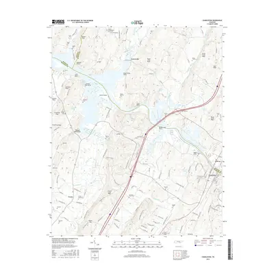
2016 Map of Charleston
USGS Topo · Published 2016About this map
The Hiwassee River serves as the central artery for this region of East Tennessee, carving a path through the ridge-and-valley landscape where Ledford Island and Sivils Bluff dominate the waterway. To the south, the settlement of Charleston sits across from Calhoun, marking a historical crossing point where rail and road infrastructure converge near the riverbank. This area is characterized by its numerous family and community burial sites, including the Charleston Community Cem, Shelton Memorial Cem, and Maddox Cem, providing a dense record of local genealogy along the valley floors.
Find a feature on this map
157 named features on this map. Tap any name to fly to it.
Don’t see what you’re looking for? This feature index may not catch every label — zoom into the map to look around manually.
Map Details
Editions of this 2016 Charleston Map
This is the sole edition of this map. No revisions or reprints were ever made.
Other maps of this area

1886 · Cleveland
USGS Topo · 1:125,000

1892 · Cleveland
USGS Topo · 1:125,000

1895 · Cleveland
USGS Topo · 1:125,000

1901 · Cleveland
USGS Topo · 1:125,000

1935 · East Cleveland
USGS Topo · 1:24,000

1935 · Calhoun
USGS Topo · 1:24,000

1935 · Benton
USGS Topo · 1:24,000

1935 · Goodfield
USGS Topo · 1:24,000

1935 · Charleston
USGS Topo · 1:24,000
1935 · Birchwood
USGS Topo · 1:24,000