
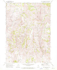
1968 Map of Charleston Reservoir
USGS Topo · Published 1971About this map
Humboldt National Forest encompasses much of this high-elevation landscape in Elko County, where the headwaters of several major drainage systems converge. The map illustrates a complex network of seasonal streams and permanent water sources, including the distinct Charleston Reservoir and Little Reservoir. The terrain is defined by its water-seeking infrastructure, with numerous Springs and named catchments like Coyote Lake scattered across the basin.
Find a feature on this map
21 named features on this map. Tap any name to fly to it.
Don’t see what you’re looking for? This feature index may not catch every label — zoom into the map to look around manually.
Map Details
Editions of this 1968 Charleston Reservoir Map
This is the sole edition of this map. No revisions or reprints were ever made.
Other maps of this area

1935 · Charleston
USGS Topo · 1:48,000

1942 · Mt. Velma
USGS Topo · 1:62,500

1955 · Wells
USGS Topo · 1:250,000

1958 · Wells
USGS Topo · 1:250,000

1961 · Wells
USGS Topo · 1:250,000

1967 · Stag Mountain
USGS Topo · 1:24,000

1967 · Hanks Creek NE
USGS Topo · 1:24,000

1968 · Marys River Basin NE
USGS Topo · 1:24,000

1968 · Marys River Basin SE
USGS Topo · 1:24,000
1968 · Marys River Basin NW
USGS Topo · 1:24,000