
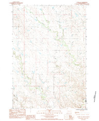
1982 Map of Chasing Hawk Draw
USGS Topo · Published 1983About this map
Cheyenne River Indian Reservation Boundary lines define the western edge of this landscape, where the borders of Ziebach and Meade counties intersect. The map records a series of prominent drainages, most notably Red Scaffold Creek and Cherry Creek, which are fed by smaller tributaries like Butcher Creek and Mud Creek. These watercourses carve out a distinct network of draws, including the eponymous Chasing Hawk Draw and Dead Horse Draw. Cultural markers in this sparsely populated area are centered on local landmarks and spiritual sites, such as the St Pius Cem and its accompanying church, alongside the Eaglestaff Cem located further south near Turtle Creek. The presence of the K C Dam suggests early efforts at water management within this prairie environment, providing a precise look at the rural infrastructure and land use in the early 1980s.
Find a feature on this map
15 named features on this map. Tap any name to fly to it.
Don’t see what you’re looking for? This feature index may not catch every label — zoom into the map to look around manually.
Map Details
Editions of this 1982 Chasing Hawk Draw Map
This is the sole edition of this map. No revisions or reprints were ever made.
Other maps of this area

1953 · Rapid City
USGS Topo · 1:250,000

1954 · Pierre
USGS Topo · 1:250,000

1957 · Rapid City
USGS Topo · 1:250,000

1958 · Pierre
USGS Topo · 1:250,000

1982 · Dead Horse Draw
USGS Topo · 1:24,000

1982 · Bull Creek 2 NE
USGS Topo · 1:24,000

1982 · Bridger NE
USGS Topo · 1:24,000

1982 · Bessie Butte
USGS Topo · 1:24,000

1982 · Red Scaffold
USGS Topo · 1:24,000
1983 · Avance SE
USGS Topo · 1:24,000