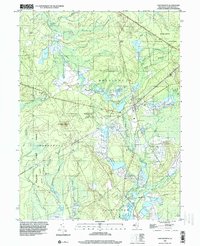
1995 Map of Chatsworth
USGS Topo · Published 2000About this map
Cranberry Bogs define the landscape of the Pine Barrens in this late 20th-century survey, illustrating a sophisticated water-management system centered around the Wading River West Branch and Wading River East Branch. The settlement of Chatsworth serves as the focal point, situated at a junction near the Chatsworth Cem and Chatsworth Lake. To the west, Apple Pie Hill rises as a prominent landmark featuring a Lookout Tower, providing a panoramic vantage point over the Chatsworth Woods.
Find a feature on this map
37 named features on this map. Tap any name to fly to it.
Don’t see what you’re looking for? This feature index may not catch every label — zoom into the map to look around manually.
Map Details
Editions of this 1995 Chatsworth Map
This is the sole edition of this map. No revisions or reprints were ever made.
Other maps of this area

1884 · Whitings
USGS Topo · 1:62,500

1888 · Pemberton
USGS Topo · 1:62,500

1888 · Little Egg Harbor
USGS Topo · 1:62,500

1888 · Whitings
USGS Topo · 1:62,500

1890 · Mullica
USGS Topo · 1:62,500

1893 · Little Egg Harbor
USGS Topo · 1:62,500

1894 · Pemberton
USGS Topo · 1:62,500

1894 · Mullica
USGS Topo · 1:62,500

1898 · Pemberton
USGS Topo · 1:62,500

1898 · Mullica
USGS Topo · 1:62,500