
1972 Map of Chelsea NW
USGS Topo · Published 1975About this map
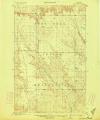
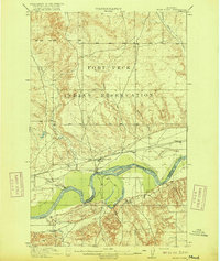
Fort Peck Indian Reservation lands dominate this topography in the early 1970s, where the winding drainage systems of Tule Creek and Chelsea Creek carve deep into the Missouri River breaks. The landscape is defined by its intermittent water sources, with scattered Spring and Springs markings indicating the vital points of relief in this arid terrain. A solitary Well is noted near the southern boundary, signifying the sparse human infrastructure needed for ranching or survival in this corner of Roosevelt County.
Find a feature on this map
13 named features on this map. Tap any name to fly to it.
Don’t see what you’re looking for? This feature index may not catch every label — zoom into the map to look around manually.
Map Details
Editions of this 1972 Chelsea NW Map
This is the sole edition of this map. No revisions or reprints were ever made.
Other maps of this area

1910 · Cuskers
USGS Topo · 1:62,500

1912 · Chelsea
USGS Topo · 1:62,500
1915 · Tule Valley
USGS Topo · 1:62,500

1915 · Cuskers
USGS Topo · 1:62,500
1916 · Wolf Point
USGS Topo · 1:62,500

1954 · Wolf Point
USGS Topo · 1:250,000

1958 · Wolf Point
USGS Topo · 1:250,000
1972 · Chelsea SW
USGS Topo · 1:24,000

1972 · Chelsea
USGS Topo · 1:24,000
1972 · Macon
USGS Topo · 1:24,000