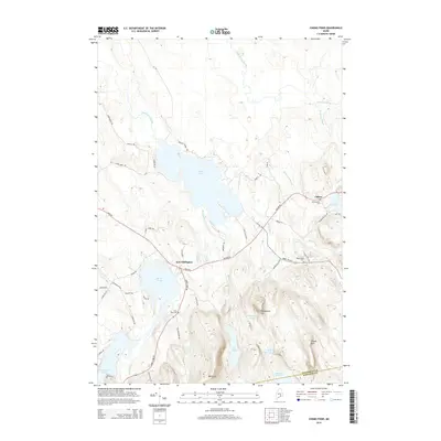
2014 Map of Chemo Pond
USGS Topo · Published 2014About this map
East Eddington and Clifton serve as the primary settlement centers in this Penobscot County landscape, situated along the historic corridor of Airline Rd and Main Rd. The topography is defined by a series of prominent elevations including Blackcap, Pisgah Mtn, and Woodchuck Hill, which overlook a complex network of glacial water bodies. Centrally located, Chemo Pond dominates the lowlands, fed by Blackman Stream and Mill Brook. For genealogists and local historians, the map preserves the locations of several community burial grounds, such as Mt Pleasant Cem near Clifton and Pine Tree Cem south of East Eddington. The transition into Hancock Co is marked at the southern edge, where the terrain rises toward Burnt Pond and Little Burnt Pond. This 2014 survey documents the established rural road network, from Jarvis Gore Rd to Nickerson Hill Rd, that connects these high-country settlements.
Find a feature on this map
59 named features on this map. Tap any name to fly to it.
Don’t see what you’re looking for? This feature index may not catch every label — zoom into the map to look around manually.
Map Details
Editions of this 2014 Chemo Pond Map
This is the sole edition of this map. No revisions or reprints were ever made.
Other maps of this area

1900 · Orland
USGS Topo · 1:62,500

1902 · Orono
USGS Topo · 1:62,500

1911 · Ellsworth
USGS Topo · 1:62,500

1929 · Great Pond
USGS Topo · 1:48,000

1932 · Great Pond
USGS Topo · 1:62,500

1940 · Ellsworth
USGS Topo · 1:62,500

1942 · Orland
USGS Topo · 1:62,500

1942 · Ellsworth
USGS Topo · 1:62,500

1944 · Orono
USGS Topo · 1:62,500

1946 · Orono
USGS Topo · 1:62,500