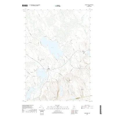
2018 Map of Chemo Pond
USGS Topo · Published 2018About this map
East Eddington and Clifton anchor this Penobscot County landscape, where the terrain is defined by a dense network of glacial ponds and wetlands. The central expanse of Chemo Pond and the sprawling Chemo Bog dominate the northern half of the sheet, feeding into Blackman Stream and the Great Works Stream. To the south, the topography rises sharply toward Pisgah Mtn and Blackcap, overlooking smaller water bodies like Little Burnt Pond and Fitts Pond. This area reflects a quiet rural character, with family-named cemeteries such as Pine Tree Cem and Mount Pleasant Cem situated near the primary crossroads. The numerous dead-end roads and fire lanes, such as Getchell Rd and FR Ln 26, suggest a landscape utilized for timber and seasonal recreation rather than dense suburban development.
Find a feature on this map
58 named features on this map. Tap any name to fly to it.
Don’t see what you’re looking for? This feature index may not catch every label — zoom into the map to look around manually.
Map Details
Editions of this 2018 Chemo Pond Map
This is the sole edition of this map. No revisions or reprints were ever made.
Other maps of this area

1900 · Orland
USGS Topo · 1:62,500

1902 · Orono
USGS Topo · 1:62,500

1911 · Ellsworth
USGS Topo · 1:62,500

1929 · Great Pond
USGS Topo · 1:48,000

1932 · Great Pond
USGS Topo · 1:62,500

1940 · Ellsworth
USGS Topo · 1:62,500

1942 · Orland
USGS Topo · 1:62,500

1942 · Ellsworth
USGS Topo · 1:62,500

1944 · Orono
USGS Topo · 1:62,500

1946 · Orono
USGS Topo · 1:62,500