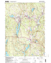
1999 Map of Chepachet
USGS Topo · Published 2000About this map
The mill villages of Burrillville and Glocester are detailed in this 1999 study of Northwest Rhode Island. The landscape is defined by its deep relationship with water power and industry along the Clear River and Branch River, connecting settlements like Harrisville, Pascoag, and Oakland. The presence of the Providence and Worcester RR and the Putnam Pike highlights the region's historical role as a transit corridor between rural uplands and industrial centers. Significant local landmarks include the Chepachet Cem, St Patricks Ch, and the sprawling Pascoag Reservoir. The terrain rises to Durfee Hill and Wolf Hill, while extensive protected lands like the George Washington State Management Area dominate the western edge, preserving the wooded character of the Blackstone Valley's western fringe.
Find a feature on this map
83 named features on this map. Tap any name to fly to it.
Don’t see what you’re looking for? This feature index may not catch every label — zoom into the map to look around manually.
Map Details
Editions of this 1999 Chepachet Map
This is the sole edition of this map. No revisions or reprints were ever made.
Other maps of this area

1886 · Blackstone
USGS Topo · 1:62,500

1889 · Blackstone
USGS Topo · 1:62,500

1889 · Webster
USGS Topo · 1:62,500

1889 · Putnam
USGS Topo · 1:62,500

1889 · Burrillville
USGS Topo · 1:62,500

1892 · Webster
USGS Topo · 1:62,500

1893 · Putnam
USGS Topo · 1:62,500

1893 · Blackstone
USGS Topo · 1:62,500

1894 · Burrillville
USGS Topo · 1:62,500

1900 · Blackstone
USGS Topo · 1:62,500
Featured Places
- Burrillville, RI
- Glocester, RI
- Mapleville, Burrillville
- Harrisville, Burrillville
- Glendale, Burrillville