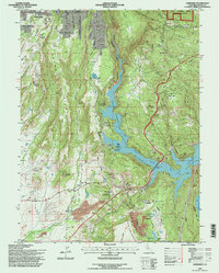
1994 Map of Cherokee
USGS Topo · Published 1997About this map
Cherokee Placer Mines dominate the southern landscape of this Butte County region, marking a legacy of hydraulic and surface mining on the flanks of North Table Mountain. The 1990s terrain is defined by the massive footprint of the Lake Oroville State Recreational Area, where the rising waters of the West Branch Feather River have reshaped the canyons below Yankee Hill. This era shows the transition of Paradise from a rural settlement toward a more developed community, complete with a Golf Course and the Paradise Airport Skypark. Cultural landmarks like the Clear Creek Cem and Mesilla Valley Sch remain as anchors for genealogists tracing family roots in the Mesilla Valley, while newer infrastructure like the Lime Saddle Powerhouse speaks to the region's mid-century hydroelectric evolution.
Find a feature on this map
51 named features on this map. Tap any name to fly to it.
Don’t see what you’re looking for? This feature index may not catch every label — zoom into the map to look around manually.
Map Details
Editions of this 1994 Cherokee Map
This is the sole edition of this map. No revisions or reprints were ever made.
Other maps of this area

1888 · Bidwell Bar
USGS Topo · 1:125,000

1891 · Bidwell Bar
USGS Topo · 1:125,000

1891 · Chico
USGS Topo · 1:125,000

1893 · Chico
USGS Topo · 1:125,000

1893 · Bidwell Bar
USGS Topo · 1:125,000

1895 · Bidwell Bar
USGS Topo · 1:125,000

1895 · Chico
USGS Topo · 1:125,000

1897 · Bidwell Bar
USGS Topo · 1:125,000

1912 · Dry Creek
USGS Topo · 1:31,680

1912 · Oroville
USGS Topo · 1:31,680