
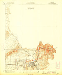
1912 Map of Oroville
USGS Topo · Published 1912About this map
Oroville and the surrounding gold-country landscape are captured here shortly after the arrival of major rail infrastructure. The city's grid is established on the banks of the Feather River, which flows past the prominent South Table Mountain. This 1910 survey highlights the town's social fabric and public institutions, specifically the Butte County Infirmary and the Odd Fellows Home near Thermalito.
Find a feature on this map
16 named features on this map. Tap any name to fly to it.
Don’t see what you’re looking for? This feature index may not catch every label — zoom into the map to look around manually.
Map Details
Editions of this 1912 Oroville Map
2 editions found
Other maps of this area

1888 · Marysville
USGS Topo · 1:125,000

1888 · Smartsville
USGS Topo · 1:125,000

1888 · Bidwell Bar
USGS Topo · 1:125,000

1891 · Bidwell Bar
USGS Topo · 1:125,000

1891 · Chico
USGS Topo · 1:125,000

1891 · Marysville
USGS Topo · 1:125,000

1891 · Smartsville
USGS Topo · 1:125,000

1892 · Smartsville
USGS Topo · 1:125,000

1893 · Chico
USGS Topo · 1:125,000

1893 · Bidwell Bar
USGS Topo · 1:125,000