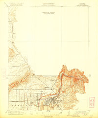
1912 Map of Oroville
USGS Topo · Published 1922About this map
Oroville and its surrounding agricultural and industrial landscape are captured here during a period of significant regional development. The town sits at the intersection of critical rail lines, including the Western Pacific, the S. P. R. R., and the Northern Electric RR, which connect the valley to the higher reaches of the Sierra foothills. The Feather River defines the lower geography, winding past the town center toward the expansive orchards and fields of Fernandez.
Find a feature on this map
15 named features on this map. Tap any name to fly to it.
Don’t see what you’re looking for? This feature index may not catch every label — zoom into the map to look around manually.
Map Details
Editions of this 1912 Oroville Map
2 editions found

Other maps of this area

1888 · Marysville
USGS Topo · 1:125,000

1888 · Smartsville
USGS Topo · 1:125,000

1888 · Bidwell Bar
USGS Topo · 1:125,000

1891 · Bidwell Bar
USGS Topo · 1:125,000

1891 · Chico
USGS Topo · 1:125,000

1891 · Marysville
USGS Topo · 1:125,000

1891 · Smartsville
USGS Topo · 1:125,000

1892 · Smartsville
USGS Topo · 1:125,000

1893 · Chico
USGS Topo · 1:125,000

1893 · Bidwell Bar
USGS Topo · 1:125,000