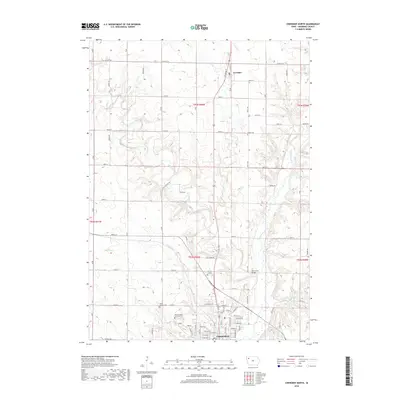
2018 Map of Cherokee North
USGS Topo · Published 2018About this map
The Little Sioux River valley dominates this Northwest Iowa landscape, carving a winding path through the rolling agricultural terrain of Cherokee County. In the south, the city of Cherokee serves as a significant hub, showing a dense grid of residential streets including Iowa St and Centennial Dr. This 2018 survey reveals a cluster of specialized landmarks on the city's outskirts, such as the Mental Health Institute Cem and Memory Gardens. To the north, the small community of Larrabee is situated near the upper reaches of Gray Cr. The area's hydrology is complex, with Mill Creek, Railroad Cr, and Badger Cr feeding into the main river system. Notable local infrastructure is documented, including the Mill Creek Bridge and several rural burial grounds like Cedar Cem and Mount Calvary Cem, providing valuable touchpoints for local genealogical research.
Find a feature on this map
49 named features on this map. Tap any name to fly to it.
Don’t see what you’re looking for? This feature index may not catch every label — zoom into the map to look around manually.
Map Details
Editions of this 2018 Cherokee North Map
This is the sole edition of this map. No revisions or reprints were ever made.
Other maps of this area

1954 · Fort Dodge
USGS Topo · 1:250,000

1957 · Fort Dodge
USGS Topo · 1:250,000

1958 · Fort Dodge
USGS Topo · 1:250,000

1969 · Aurelia
USGS Topo · 1:24,000

1969 · Cleghorn
USGS Topo · 1:24,000

1969 · Cherokee South
USGS Topo · 1:24,000
1969 · Quimby
USGS Topo · 1:24,000

1971 · Peterson SW
USGS Topo · 1:24,000
1971 · Paullina
USGS Topo · 1:24,000
1971 · Sutherland West
USGS Topo · 1:24,000