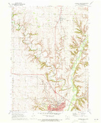
1971 Map of Cherokee North
USGS Topo · Published 1973About this map
The Little Sioux River valley carves through the landscape of Cherokee County in the early 1970s, anchoring the development of the city of Cherokee and the northern settlement of Larrabee. The river's winding path is flanked by the Illinois Central railroad, a corridor that supported the region's agricultural and industrial growth. To the north, the small community of Larrabee serves as a rural outpost, while the southern portion of the map reveals the institutional and civic layout of the county seat. Notable sites include the expansive Cherokee State Hospital complex and several educational landmarks such as Wilson Jr High Sch and Roosevelt Sch. Cultural markers of the era are visible in the Drive-in Theater and local gathering spots like the Country Club. The map also meticulously records local heritage through several burial grounds, including Mt Calvary Cem and Memory Gardens, providing a record for genealogical research.
Find a feature on this map
31 named features on this map. Tap any name to fly to it.
Don’t see what you’re looking for? This feature index may not catch every label — zoom into the map to look around manually.
Map Details
Editions of this 1971 Cherokee North Map
This is the sole edition of this map. No revisions or reprints were ever made.
Other maps of this area

1954 · Fort Dodge
USGS Topo · 1:250,000

1957 · Fort Dodge
USGS Topo · 1:250,000

1958 · Fort Dodge
USGS Topo · 1:250,000

1969 · Aurelia
USGS Topo · 1:24,000

1969 · Cleghorn
USGS Topo · 1:24,000

1969 · Cherokee South
USGS Topo · 1:24,000
1969 · Quimby
USGS Topo · 1:24,000

1971 · Peterson SW
USGS Topo · 1:24,000
1971 · Paullina
USGS Topo · 1:24,000
1971 · Sutherland West
USGS Topo · 1:24,000