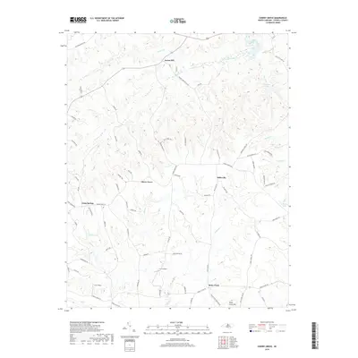
2019 Map of Cherry Grove
USGS Topo · Published 2019About this map
Locust Hill and Cherry Grove anchor this 2019 survey of south-central Caswell County, where the Piedmont landscape is defined by the winding course of Country Line Cr and its numerous tributaries. The topography rises toward the southeast at Stony Creek Mtn, overlooking the community of Stony Creek. This modern landscape retains a significant network of rural roads and family-named landmarks, such as Butler Pond, reflecting a settlement pattern that has persisted through generations. Small-scale aviation is a notable feature of the area, evidenced by the K & D Airport and the H & J Strip located near Pagetown Rd. Water remains a central element of the geography, from the larger Williams Lake and Boy Scout Lake to smaller streams like Benton Br and Hostler Br, which carve the undulating terrain of this traditional North Carolina tobacco-growing region.
Find a feature on this map
73 named features on this map. Tap any name to fly to it.
Don’t see what you’re looking for? This feature index may not catch every label — zoom into the map to look around manually.
Map Details
Editions of this 2019 Cherry Grove Map
This is the sole edition of this map. No revisions or reprints were ever made.
Other maps of this area

1953 · Greensboro
USGS Topo · 1:250,000

1954 · Greensboro
USGS Topo · 1:250,000

1962 · Greensboro
USGS Topo · 1:250,000

1966 · Greensboro
USGS Topo · 1:250,000

1969 · Lake Burlington
USGS Topo · 1:24,000

1969 · Burlington NE
USGS Topo · 1:24,000

1970 · Ossipee
USGS Topo · 1:24,000
1971 · Ruffin
USGS Topo · 1:24,000
1972 · Anderson
USGS Topo · 1:24,000
1972 · Williamsburg
USGS Topo · 1:24,000