
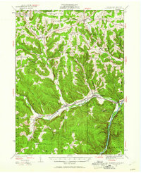
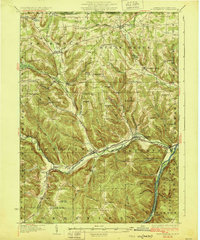
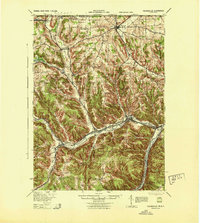
1947 Map of Cherry Grove
USGS Topo · Published 1972About this map
Cherry Springs Park serves as a central landmark in this high-elevation landscape, where the plateau terrain is deeply incised by the headwaters of several regional river systems. The map illustrates a complex network of timber and access trails, such as the Boone Trail and Colliersport Trail, which reflect the area's legacy of forest management and early twentieth-century recreation. While the small settlement of Lyman and the nearby Lyman Run Camp are situated along the northern drainages, the southern portion of the sheet is defined by the steep descent toward the East Fork Sinnemahoning Creek. Transportation history is visible through the path of the Coudersport and Port Allegany Railroad and the high-elevation Cherry Springs Airport, providing a clear picture of how this remote Potter County terrain was utilized for both industry and public service before more modern developments took hold.
Find a feature on this map
73 named features on this map. Tap any name to fly to it.
Don’t see what you’re looking for? This feature index may not catch every label — zoom into the map to look around manually.
Map Details
Editions of this 1947 Cherry Grove Map
This is the sole edition of this map. No revisions or reprints were ever made.
Other maps of this area

1906 · Warren
USGS Topo · 1:62,500

1907 · Warren
USGS Topo · 1:62,500

1908 · Warren
USGS Topo · 1:62,500
1926 · Youngsville
USGS Topo · 1:62,500

1927 · Tidioute
USGS Topo · 1:48,000
1929 · Youngsville
USGS Topo · 1:62,500

1930 · Tidioute
USGS Topo · 1:62,500

1935 · Sheffield
USGS Topo · 1:48,000

1941 · Sheffield
USGS Topo · 1:62,500
1943 · Youngsville
USGS Topo · 1:62,500
Featured Places
- Cherry Grove Township, PA
- Watson Township, PA
- Hermit Spring, Cherry Grove Township
- Howe Township, PA
- Mead Township, PA