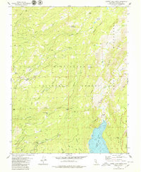
1979 Map of Cherry Lake North
USGS Topo · Published 1979About this map
Cherry Lake anchors the southeastern corner of this High Sierra landscape, with underwater contours provided by Pacific Gas & Electric Co. showing the submerged terrain of the reservoir at an elevation of 4700 feet. The map details a transition from the managed timberlands of the Stanislaus National Forest into the protected wilderness of the Emigrant Wilderness and the northwestern edge of Yosemite National Park.
Find a feature on this map
39 named features on this map. Tap any name to fly to it.
Don’t see what you’re looking for? This feature index may not catch every label — zoom into the map to look around manually.
Map Details
Editions of this 1979 Cherry Lake North Map
2 editions found
Other maps of this area

1891 · Big Trees
USGS Topo · 1:125,000

1893 · Sonora
USGS Topo · 1:125,000

1894 · Big Trees
USGS Topo · 1:125,000

1896 · Dardanelles
USGS Topo · 1:125,000

1896 · Sonora
USGS Topo · 1:125,000

1897 · Sonora
USGS Topo · 1:125,000

1897 · Big Trees
USGS Topo · 1:125,000

1897 · Yosemite
USGS Topo · 1:125,000

1898 · Dardanelles
USGS Topo · 1:125,000

1898 · Sonora
USGS Topo · 1:125,000