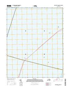
2016 Map of Chesapeake Channel
USGS Topo · Published 2016About this map
Chesapeake Bay is defined here by the massive engineering of the Chesapeake Bay Bridge-Tunnel, which spans the mouth of the bay where it meets the Atlantic Ocean. This map documents the complex intersection of deep-water transit and shallow maritime hazards. The Chesapeake Channel and the Chesapeake Channel Tunnel facilitate heavy shipping, while the surrounding waters are marked by significant sandbanks and shallows. These include Middle Ground, Inner Middle Ground, White Shoal, and Nine Foot Shoal. The path of the Intracoastal Waterway cuts through the western portion of the sheet, and the North Channel is visible to the northeast. The boundary for Northampton Co traverses the open water, illustrating the political division of these vital coastal waters.
Find a feature on this map
15 named features on this map. Tap any name to fly to it.
Don’t see what you’re looking for? This feature index may not catch every label — zoom into the map to look around manually.
Map Details
Editions of this 2016 Chesapeake Channel Map
This is the sole edition of this map. No revisions or reprints were ever made.
Other maps of this area

1893 · Virginia Beach
USGS Topo · 1:125,000

1907 · Norfolk
USGS Topo · 1:125,000

1918 · Cape Henry
USGS Topo · 1:62,500

1919 · Cape Henry
USGS Topo · 1:62,500

1943 · Elliots Creek
USGS Topo · 1:25,000

1943 · Townsend
USGS Topo · 1:24,000

1943 · Richmond
USGS Topo · 1:250,000

1946 · Eastville
USGS Topo · 1:250,000

1946 · Currituck Sound
USGS Topo · 1:250,000

1948 · Ocean View
USGS Topo · 1:24,000