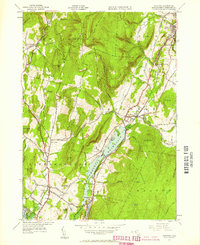
1944 Map of Cheshire
USGS Topo · Published 1958About this map
The Hoosic River valley forms the industrial and transport backbone of this Berkshire County landscape, where the Boston and Albany Railroad parallels the water to serve a string of small mill settlements. Communities like Maple Grove, Arnoldsville, Cheshire Harbor, and Berkshire are clustered along this corridor, reflecting the region's 19th-century manufacturing heritage. The central Cheshire Reservoir dominates the lowlands, while the western heights are defined by the steep ascent toward Saddle Ball Mountain and Jones Nose. This survey, based on 1940s planetable work, captures a transition point in the local economy as the rugged terrain of the Appalachian Trail remained largely undeveloped compared to the active Quarry sites and established hill farms. Local landmarks such as the Stone Sch and family-named elevations like Farnham Hill and Savage Hill provide specific points of interest for genealogists and local historians.
Find a feature on this map
85 named features on this map. Tap any name to fly to it.
Don’t see what you’re looking for? This feature index may not catch every label — zoom into the map to look around manually.
Map Details
Editions of this 1944 Cheshire Map
2 editions found
Other maps of this area

1886 · Greylock
USGS Topo · 1:62,500

1886 · Becket
USGS Topo · 1:62,500

1888 · Becket
USGS Topo · 1:62,500

1888 · Berlin
USGS Topo · 1:62,500

1888 · Pittsfield
USGS Topo · 1:62,500

1890 · Pittsfield
USGS Topo · 1:62,500

1890 · Berlin
USGS Topo · 1:62,500

1891 · Greylock
USGS Topo · 1:62,500

1893 · Becket
USGS Topo · 1:62,500

1893 · Greylock
USGS Topo · 1:62,500