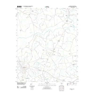
2011 Map of Chesnee
USGS Topo · Published 2011About this map
Chesnee and the neighboring community of Cliffside define the landscape of this borderland area where South Carolina meets North Carolina. The State Line cuts horizontally across the terrain, separating Spartanburg County from the northern foothills. This region is marked by a high density of family and community burial grounds, including the Burke Cemetery, Painter Cemetery, and Crestview Cemetery, which offer valuable data for genealogical research. Water is a dominant feature throughout the quadrangle, with the Broad River and its tributary Suck Creek winding through the countryside, alongside numerous local impoundments such as Harris Lake and Jolleys Lake. The presence of Spicers Airport and the Burlington Dam suggests a mix of 20th-century utility and local infrastructure. Small settlements like Brice and Harris are linked by a network of rural routes including Island Ford Rd and Ferry Rd, reflecting the area's transition from early river-based crossings to modern road networks.
Find a feature on this map
163 named features on this map. Tap any name to fly to it.
Don’t see what you’re looking for? This feature index may not catch every label — zoom into the map to look around manually.
Map Details
Editions of this 2011 Chesnee Map
This is the sole edition of this map. No revisions or reprints were ever made.
Other maps of this area

1909 · Gaffney
USGS Topo · 1:62,500

1950 · Shelby
USGS Topo · 1:62,500

1953 · Charlotte
USGS Topo · 1:250,000

1954 · Charlotte
USGS Topo · 1:250,000

1959 · Cowpens
USGS Topo · 1:62,500

1960 · Charlotte
USGS Topo · 1:250,000

1962 · Charlotte
USGS Topo · 1:250,000

1966 · Forest City
USGS Topo · 1:24,000
1966 · Rutherfordton South
USGS Topo · 1:24,000
1971 · Boiling Springs South
USGS Topo · 1:24,000