
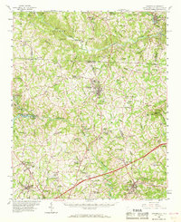
1959 Map of Cowpens
USGS Topo · Published 1961About this map
Cowpens National Battlefield stands as a focal point in this upstate landscape, reflecting the commemorative history of the American Revolution amidst a mid-century agricultural and industrial setting. The survey reveals a region defined by the drainage of the Broad River and Pacolet River, where small settlements like Chesnee and Cowpens grew alongside the Southern railroad line. The presence of numerous country churches, such as Hicks Grove Ch and Providence Ch, and schools like Foster Grove Sch indicates a landscape of tight-knit rural communities before the onset of significant suburban expansion. Near the northern border, the textile heritage of the region is evident at Cliffside, while the South Pacolet River Reservoir No 1 and Rainbow Lake show the importance of water management for the growing local populations in Spartanburg and Cherokee Counties.
Find a feature on this map
95 named features on this map. Tap any name to fly to it.
Don’t see what you’re looking for? This feature index may not catch every label — zoom into the map to look around manually.
Map Details
Editions of this 1959 Cowpens Map
2 editions found
Other maps of this area

1907 · Saluda
USGS Topo · 1:125,000

1909 · Gaffney
USGS Topo · 1:62,500

1935 · Greer
USGS Topo · 1:48,000

1938 · Greer
USGS Topo · 1:62,500

1941 · Spartanburg
USGS Topo · 1:250,000

1947 · Spartanburg
USGS Topo · 1:62,500

1949 · Spartanburg
USGS Topo · 1:24,000

1949 · Spartanburg
USGS Topo · 1:62,500

1950 · Shelby
USGS Topo · 1:62,500

1953 · Spartanburg
USGS Topo · 1:250,000