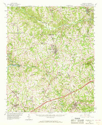
1959 Map of Cowpens
USGS Topo · Published 1968About this map
Cowpens National Battlefield and the Cowpens Monument anchor the center of this map, marking the site of the pivotal American Revolutionary War engagement. The landscape of the late 1950s reveals a region defined by the convergence of the Clinchfield and Southern railroads, which facilitated the growth of textile and industrial settlements like Cliffside, Henrietta, and Chesnee. Water resources are central to the local economy, shown through infrastructure like the South Pacolet River Reservoir No 1 and its associated Filtration Plant, alongside numerous family-named landmarks and rural congregations such as Jerusalem Ch and New Hope Ch. The border between North and South Carolina bisects the sheet, following the divide between Spartanburg and Rutherford counties. This era of development is captured through the expansion of local educational centers like Chase High Sch and recreational spots including Rainbow Lake and Cannons Camp Ground.
Find a feature on this map
126 named features on this map. Tap any name to fly to it.
Don’t see what you’re looking for? This feature index may not catch every label — zoom into the map to look around manually.
Map Details
Editions of this 1959 Cowpens Map
2 editions found

Other maps of this area

1907 · Saluda
USGS Topo · 1:125,000

1909 · Gaffney
USGS Topo · 1:62,500

1935 · Greer
USGS Topo · 1:48,000

1938 · Greer
USGS Topo · 1:62,500

1941 · Spartanburg
USGS Topo · 1:250,000

1947 · Spartanburg
USGS Topo · 1:62,500

1949 · Spartanburg
USGS Topo · 1:24,000

1949 · Spartanburg
USGS Topo · 1:62,500

1950 · Shelby
USGS Topo · 1:62,500

1953 · Spartanburg
USGS Topo · 1:250,000