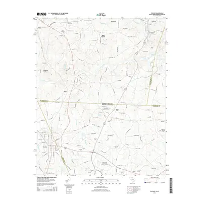
2014 Map of Chesnee
USGS Topo · Published 2014About this map
Cowpens National Battlefield occupies the southern portion of this landscape, marking the historic Piedmont site where the state lines of North and South Carolina meet. The town of Chesnee serves as a local hub near the Spartanburg and Cherokee county line, where Us-221 transitions from South Carolina toward the North Carolina settlements of Harris and Henrietta. The terrain is defined by the winding course of the Broad River and the Second Broad River, which feed into numerous smaller tributaries like Cherokee Creek and Suck Creek. Genealogists will find a high density of family and community burial sites, including Floyds Creek Cemetery, Scruggs Cemetery, and Johnson Cemetery. Small-scale aviation is a distinct modern feature of the region, evidenced by Davis Field Airport, Boomerang Airport, and the State Line Ultraport.
Find a feature on this map
159 named features on this map. Tap any name to fly to it.
Don’t see what you’re looking for? This feature index may not catch every label — zoom into the map to look around manually.
Map Details
Editions of this 2014 Chesnee Map
This is the sole edition of this map. No revisions or reprints were ever made.
Other maps of this area

1909 · Gaffney
USGS Topo · 1:62,500

1950 · Shelby
USGS Topo · 1:62,500

1953 · Charlotte
USGS Topo · 1:250,000

1954 · Charlotte
USGS Topo · 1:250,000

1959 · Cowpens
USGS Topo · 1:62,500

1960 · Charlotte
USGS Topo · 1:250,000

1962 · Charlotte
USGS Topo · 1:250,000

1966 · Forest City
USGS Topo · 1:24,000
1966 · Rutherfordton South
USGS Topo · 1:24,000
1971 · Boiling Springs South
USGS Topo · 1:24,000