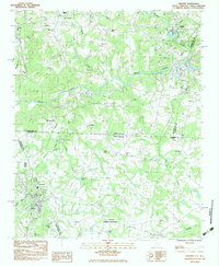
1983 Map of Chesnee
USGS Topo · Published 1983About this map
Cowpens National Battlefield anchors the southern portion of this landscape, marking a site of immense regional significance near the border of Spartanburg Co Cherokee Co. The terrain is defined by the winding paths of the Broad River and its primary tributary, the Second Broad River, which flow through a network of small agricultural and textile-related communities. The settlement of Chesnee sits as a central hub in South Carolina, while to the north in North Carolina, Cliffside and Harris appear along the river corridors. Transport patterns are shaped by the Seaboard railroad line, which cuts through the hills to connect these industrial outposts. The map reveals a dense social fabric tied to the land, evidenced by numerous rural meeting houses such as Jerusalem Ch, High Shoals Ch, and Brice Ch, as well as local landmarks like Jolleys Lake and the County Memorial Cem.
Find a feature on this map
45 named features on this map. Tap any name to fly to it.
Don’t see what you’re looking for? This feature index may not catch every label — zoom into the map to look around manually.
Map Details
Editions of this 1983 Chesnee Map
This is the sole edition of this map. No revisions or reprints were ever made.
Other maps of this area

1909 · Gaffney
USGS Topo · 1:62,500

1950 · Shelby
USGS Topo · 1:62,500

1953 · Charlotte
USGS Topo · 1:250,000

1954 · Charlotte
USGS Topo · 1:250,000

1959 · Cowpens
USGS Topo · 1:62,500

1960 · Charlotte
USGS Topo · 1:250,000

1962 · Charlotte
USGS Topo · 1:250,000

1966 · Forest City
USGS Topo · 1:24,000
1966 · Rutherfordton South
USGS Topo · 1:24,000
1971 · Boiling Springs South
USGS Topo · 1:24,000