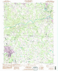
1993 Map of Chesnee
USGS Topo · Published 1996About this map
Chesnee sits at the southern edge of this Piedmont landscape, a region defined by the winding course of the Broad River and the historic state line dividing the Carolinas. In the early 1990s, the area maintained a rural character shaped by small settlements like Harris and Cliffside and a network of community landmarks such as High Shoals Ch and Floyds Creek Ch. The presence of Cowpens National Battlefield at the southern margin provides a significant historical anchor for the terrain, marking the site of a pivotal Revolutionary War engagement. Water features like Jolleys Lake and Scruggs Lake break the wooded topography, while a cluster of institutional sites, including Chase High Sch and County Memorial Cem, reflects the social and educational geography of the borderlands between Spartanburg, Cherokee, and Rutherford counties.
Find a feature on this map
41 named features on this map. Tap any name to fly to it.
Don’t see what you’re looking for? This feature index may not catch every label — zoom into the map to look around manually.
Map Details
Editions of this 1993 Chesnee Map
This is the sole edition of this map. No revisions or reprints were ever made.
Other maps of this area

1909 · Gaffney
USGS Topo · 1:62,500

1950 · Shelby
USGS Topo · 1:62,500

1953 · Charlotte
USGS Topo · 1:250,000

1954 · Charlotte
USGS Topo · 1:250,000

1959 · Cowpens
USGS Topo · 1:62,500

1960 · Charlotte
USGS Topo · 1:250,000

1962 · Charlotte
USGS Topo · 1:250,000

1966 · Forest City
USGS Topo · 1:24,000
1966 · Rutherfordton South
USGS Topo · 1:24,000
1971 · Boiling Springs South
USGS Topo · 1:24,000